Introduction

Mobility Justice for Route 82
“Transportation justice describes a normative condition in which no person or group is disadvantaged by a lack of access to the opportunities they need to lead a meaningful and dignified life.” (Karner et al., 2020)
While there are important amenities along Route 82, the impacts of systemic disinvestment manifest in a relatively low density of businesses in North Lawndale. This means residents must leave the community to access amenities that fully meet their needs. Frequent and reliable transit service is one piece of the mobility justice puzzle; however, equitable access to places of employment, worship, communal gatherings, and other essential services within a reasonable travel time is equally important. For example, a fifteen-minute bus ride in an affluent, White neighborhood like Lincoln Park should grant residents access to the same number of amenities as a fifteen-minute bus ride in North Lawndale. The significant disparity in access to amenities in North Lawndale means the criteria for transportation justice have not been met. Unfortunately, a direct quantitative comparison of amenities between community areas is beyond this report’s scope. However, the project team used existing data to assess access within the Frequency and Reliability Analysis and Bus Stop Audit.
Beyond amenities, reliable transit service offers a space for transit affinities, conversations that “help Black passengers pass the time, but also provide them with helpful information, an outlet for voicing their frustrations with racism, freedom to express their own racially insensitive ideas, and the space to voice political discontent.”28 As a majority Black community, North Lawndale benefits from a place for these valuable relationships—a sort of mobile “quasi-community”—to form, especially when traveling north on Route 82 and away from predominantly Black neighborhoods.29
Amenities
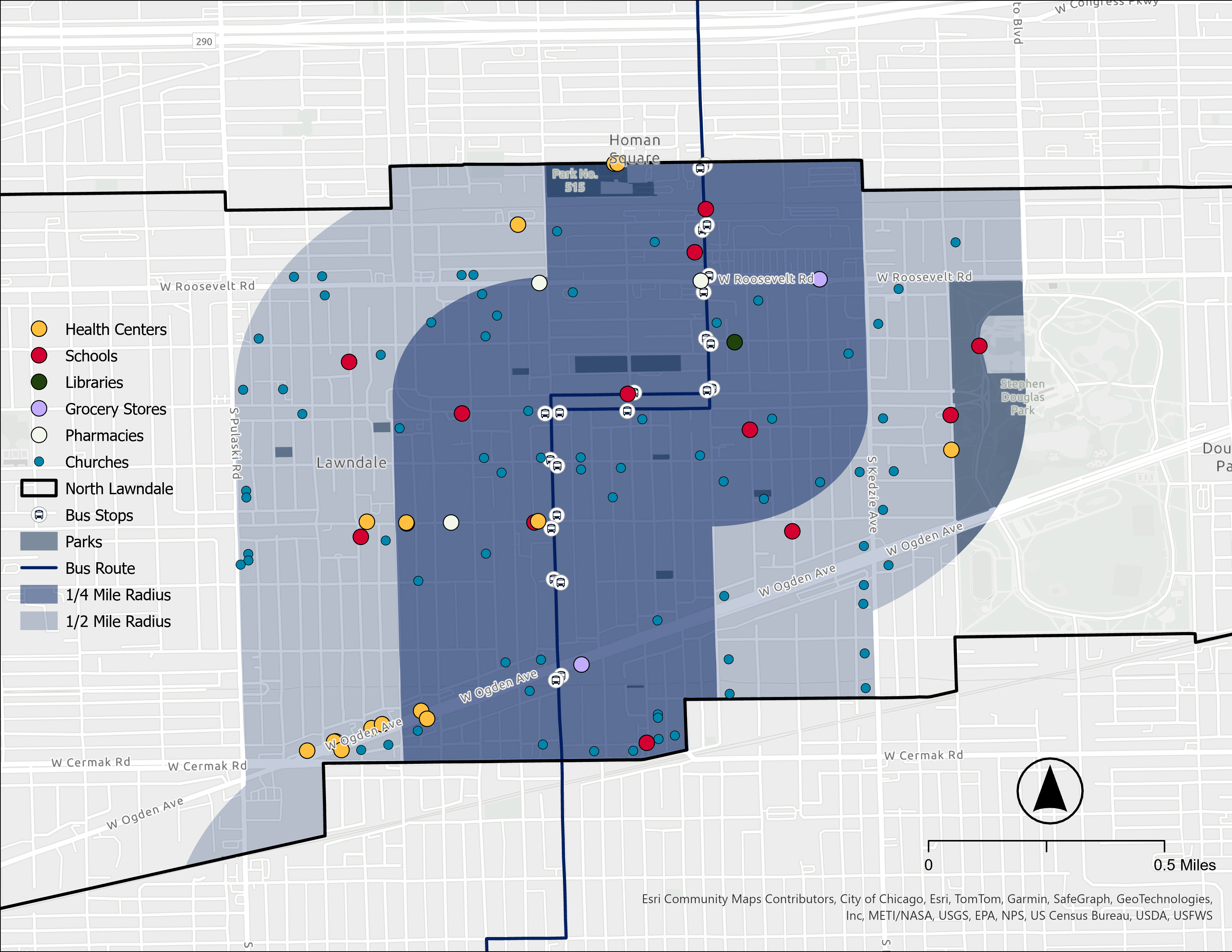
Route 82 serves as a vital connector to gathering spaces, fostering social cohesion both outside and inside the bus. From Douglass Park’s natural spaces and recreation opportunities to spiritual congregation in places of worship, Route 82 presents residents with opportunities for interpersonal connection (see Figure 7). Furthermore, goods and services that foster community development and health are close to the route. Important health centers such as the Lawndale Christian Health Center are within a half-mile radius of Route 82 (see Figure 7). Access to fresh, nutritious foods and groceries is critical for residents’ health and well-being. Route 82 serves full-service grocery store Leamington Foods, as well as the Farm on Ogden. This community farm houses an organic vegetable garden, aquaponics facility, commercial kitchen, a small market selling fresh produce, and community educational programming.30 Two pharmacies are easily accessible from bus stops along the route. Several educational institutions and a public library also follow the route (see Figure 7). These amenities transform Route 82 from a typical transportation artery to a lifeline for North Lawndale residents.
Transportation
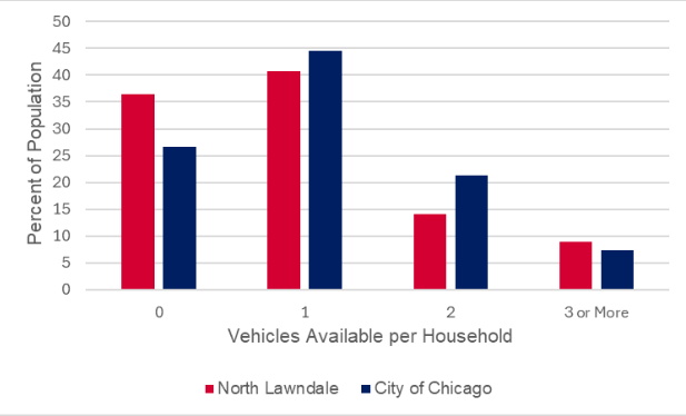
The number of existing amenities along Route 82 makes it essential to the community. The route serves grocery stores, healthcare, education, and civic centers, easing the pressures of disinvestment and marginalization on community members. On average, North Lawndale residents have less access to personal vehicles than other communities (see Figure 8). Furthermore, the higher rate of residents who are elderly and have a disability compounds mobility and socioeconomic vulnerability. Delays or uncomfortable bus stops present compounding barriers to amenity access. These frequently overlooked barriers perpetuate cyclical disinvestment. Mobility justice envisions a Route 82 that enables all residents, regardless of income or ability, equitable access to local goods and services.
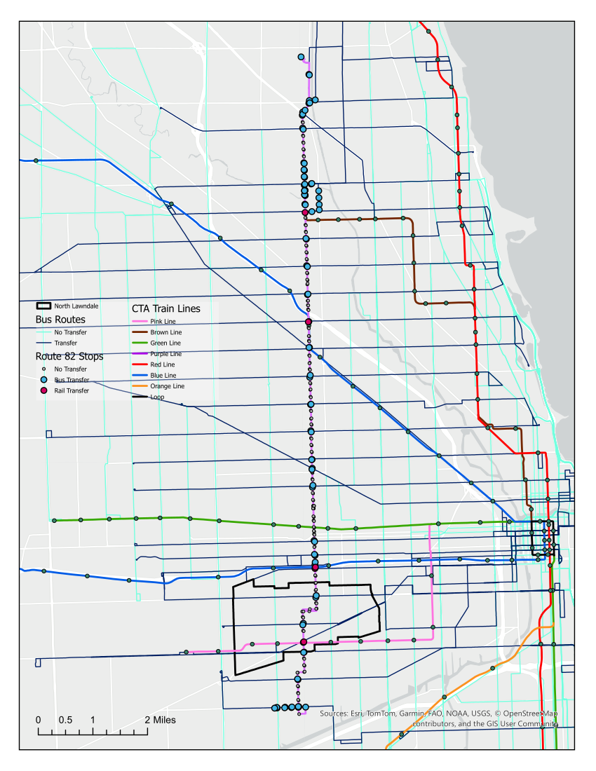
Route 82 also provides vital connections to other transit routes, including bus routes 12-Roosevelt, 18-16th/18th, 157-Streeterville/Taylor, and 21-Cermak (see Figure 9). The route offers transfers to the Pink Line at Central Park and to the Blue Line at Kedzie-Homan just outside of North Lawndale (see Figure 10). Connections between different routes enable riders to have more flexibility in their travel by allowing them to access destinations that are not on bus routes. This flexibility does come at a cost, as each transfer adds an average of 8:25 minutes to each trip within Chicago when controlling for distance and transit mode.
Compared to other community areas along Route 82, North Lawndale has more transit connections than the CTA average of 3.33 (see Table 1). The transit connectivity of Route 82 in North Lawndale provides additional flexibility and accessibility to riders, highlighting the local importance of Route 82.
| Community area | Bus-to-bus | Bus-to-train | Total connections |
|---|---|---|---|
| Little Village34 | 3 | 0 | 3 |
| North Lawndale | 3 | 1 | 4 |
| East Garfield Park | 3 | 2 | 5 |
| Humboldt Pak | 4 | 0 | 4 |
| Logan Square | 3 | 1 | 4 |
| Avondale | 2 | 0 | 2 |
| Irving Park | 2 | 0 | 2 |
| Albany Park | 1 | 1 | 2 |
| North Park | 4 | 0 | 4 |
| Route average | 2.78 | 0.56 | 3.33 |
| Source: City of Chicago. (2024). City of Chicago data portal. Retrieved November 19, 2024, from https://data.cityofchicago.org/ (See Appendix for specific sources). | |||
Education
Route 82 also serves North Lawndale’s school-age residents, who made up 22.9 percent of the community’s population in 2022. Notably, high school students are more likely than younger students to take transit to school on their own without the help of parents. Chicago’s school system is still reeling from the 2013 closure of 50 schools—mostly in Black and Hispanic/Latino communities on the city’s South and West sides. These closures included two schools within North Lawndale. Many shuttered schools were classified as “neighborhood” schools, serving all students from the local enrollment district. Today, students without neighborhood high schools often opt to attend a magnet, private, or charter school across the city through a competitive enrollment system. In the US, enrollment in non-local schools is higher among minority students than white students, “highlighting the importance of accessing educational opportunities for historically disadvantaged communities” such as North Lawndale.
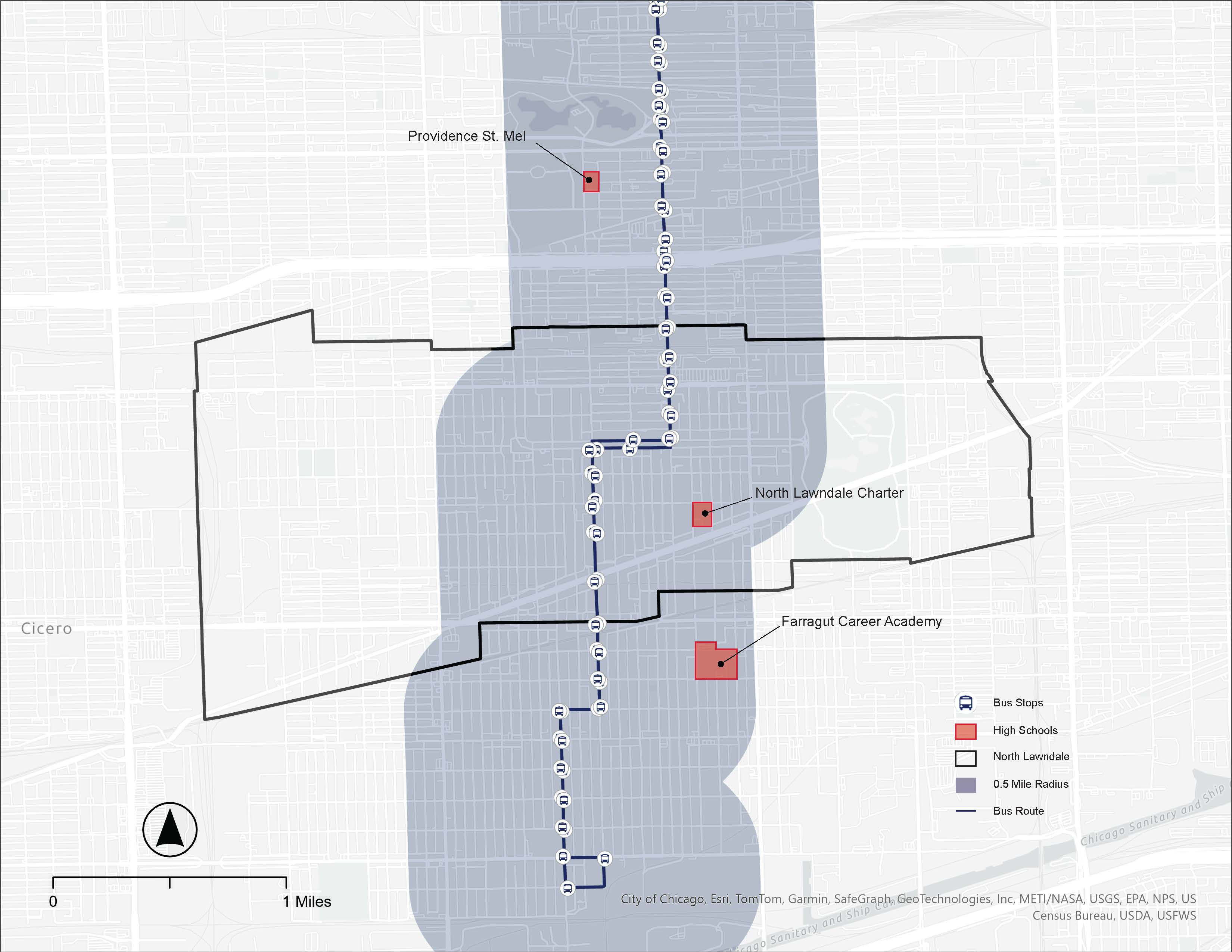
For students with limited transportation options—including working parents and/or one or fewer cars in their household—public transit significantly increases a student’s likelihood of attending an impactful after-school program. Only three high schools are within a half-mile of a Route 82 bus stop in North Lawndale, Little Village, or East Garfield Park (see Figure 11). Of these high schools, only one is a neighborhood high school—Farragut Career Academy, located in Little Village. Today, North Lawndale lacks a neighborhood high school that is open to any student. This report does not focus on schools students may be traveling to more than a few miles outside of North Lawndale, as this is outside of the project’s neighborhood-focused scope. However, these three schools are important amenities of Route 82, and community partner observation confirmed that students make up a high percentage of Route 82 riders during weekday commute hours.
Environment
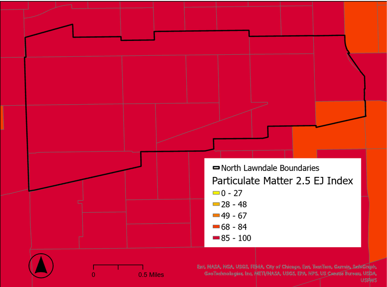
Environmental Justice (EJ) is an important component of mobility justice. The U.S. Environmental Protection Agency (EPA) defines EJ as “providing an environment where all people enjoy the same degree of protection from environmental and health hazards and equal access to the decision-making process to maintain a healthy environment in which to live, learn, and work.” Communities experiencing disproportionate environmental hazards and climate change vulnerability require safe, accessible, and frequent public transportation. North Lawndale is almost completely within the 85-100th percentile in Illinois for exposure to particulate matter 2.5 according to the EPA’s EJ Screening and Mapping Tool, as shown in Figure 12 below. Across traffic proximity, air pollution metrics, and health metrics, North Lawndale is also in the 85-100th percentile.
The urban heat island is already a significant concern in Chicago, but it will worsen with climate change. Days over 95°F will increase from two days annually to 18 days by mid-century. While this is an alarming projection, trees can help mitigate the urban heat island effect by providing shade and reducing the air temperature. United States Department of Agriculture (USDA) Forestry Service data visualizes the existing percentage of tree canopy cover along Route 82.
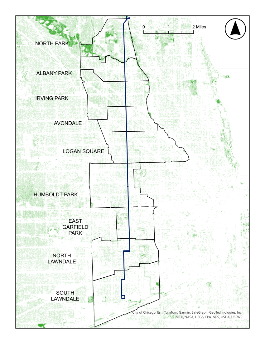
North Lawndale’s percentage of tree canopy coverage is currently 18 percent, just below Chicago’s citywide tree canopy coverage of 20 percent. While there is denser canopy coverage in Douglass Park and on Douglass Boulevard, North Lawndale’s other streets are sparsely populated with vegetation (see Figure 13). North Lawndale is most similar to its northern neighbor, East Garfield Park, while Little Village has even less tree canopy coverage at just 15 percent. The average tree canopy coverage by community area is 20.76 percent, placing North Lawndale below average. Tree canopy coverage rates south of Addison Street tend to be lower, aligning with North Lawndale. As Route 82 travels north, tree canopy coverage rates generally increase. North Park, at the city’s northern boundary, has the highest tree canopy coverage by far at 33 percent. Notably, the LaBagh Woods are partially located in this community area. Table 2 contains tree canopy coverage data for each of the Chicago community areas along Route 82.
| Community area | Tree canopy coverage (percent) |
|---|---|
| Little Village | 15 |
| North Lawndale | 18 |
| East Garfield Park | 18 |
| Humbold Park | 17 |
| Logan Square | 20 |
| Avondale | 16 |
| Albany Park | 25 |
| North Park | 33 |
| Route Average | 20.78 |
| Source: “Community Tree Canopy Summaries,” Chicago Region Tree Initiative, Chicago, IL: Openlands, 2020, https://mortonarb.org/plant-and-protect/chicago-region-trees-initiative/community-tree-canopy-summaries/. |
The Chicago Metropolitan Agency for Planning (CMAP) published a Transit Rider Vulnerability Analysis as part of its multi-part Transportation Resilience Improvement Plan. Refer to the Appendix for an explanation of each component in CMAP’s Transit Rider Vulnerability methodology. The assessment relies on the social and health vulnerability of where people live, not who is riding transit. This means the results are specific to Route 82 riders who live in North Lawndale.
Of the 22 Route 82 bus stops in North Lawndale, all are scored as having “very high” vulnerability. This score is a factor of social vulnerability, health vulnerability, and the projected number of days over 95°F in North Lawndale by mid-century. Transit riders in North Lawndale are more vulnerable to extreme heat than other community areas on Route 82. Most bus stops along the route have a “high” vulnerability score—48 percent of all bus stops. Only 26 percent of all bus stops on Route 82 have “very high” vulnerability, including all stops in North Lawndale. While 46 percent of all “very high” scoring bus stops along the route are located in North Lawndale, there are also stops in Little Village and East Garfield Park. Table 4 contains transit rider vulnerability data for each Chicago community area along Route 82.
| Community area | Bus stop scores (percent) | |||
|---|---|---|---|---|
| Very high | High | Medium | Low | |
| Little Village | 100 | 0 | 0 | 0 |
| North Lawndale | 100 | 0 | 0 | 0 |
| East Garfield Park | 23 | 77 | 0 | 0 |
| Humboldt Pak | 0 | 100 | 0 | 0 |
| Logan Square | 0 | 11 | 89 | 0 |
| Avondale | 0 | 78 | 22 | 0 |
| Irving Park | 0 | 40 | 60 | 0 |
| Albany Park | 0 | 100 | 0 | 0 |
| North Park | 0 | 33 | 67 | 0 |
| Route Average | 26 | 48 | 26 | 9 |
As climate change intensifies, existing issues like heat inequality will only worsen. The environment’s disproportionate impact on transit provides justification for this report’s bus stop audit. If North Lawndale residents relying on Route 82 do not have access to shaded structures while waiting, or if their wait times are extraordinarily long, they will be more susceptible to the adverse health effects of extreme heat. Without frequent and reliable service along Route 82, residents waiting at stops may also experience prolonged, extreme exposure to airborne pollutants.
Justification for Study
Given the unique history and characteristics of North Lawndale, a mobility justice study of one of its most important bus routes is not only justifiable, but necessary. According to the Federal Transit Administration, the governing body in charge of enforcing Title VI of the Civil Rights Act of 1964, Title VI “protects people from discrimination based on race, color, and national origin in programs and activities receiving federal financial assistance.” The CTA receives federal funding and therefore must abide by Title VI standards to ensure equitable service. The project team completed a study on frequency and reliability relative to the CTA’s service standards. This study also compares CTA frequency and reliability standards to peer transit agencies to determine the efficacy of the CTA’s standards in enforcing equitable service.
Bus stop quality along Route 82 is another important aspect of service. Factors like shade, seating, and accessibility features affect riders’ comfort and safety while waiting at bus stops. To determine the equitability of Route 82 bus stops in North Lawndale, the report team conducted a bus stop audit. Comparing bus stop assets along the route to industry standards through the lens of mobility justice holds accountable the public and private agencies that have historically disinvested in majority Black, low-income neighborhoods like North Lawndale.
An equitable transportation network, including buses and bus stop infrastructure, are crucial in supporting reinvestment in the community by serving places like Farm on Ogden and Lawndale Christian Health Center. The frequency and reliability study and bus stop audit presented in this report aim to help support a continued focus on these efforts.
Continue Reading: Frequency and Reliability
